The first thing we set up on a Maple Ridge slope is a robotic total station with a telemetric link, backed by a string of piezometers and inclinometer casings. The terrain here doesn't give second chances. The municipality sits on a complex mix of Vashon till, glaciomarine silts, and colluvial blankets draped over bedrock that outcrops unpredictably along the Alouette and Kanaka Creek valleys. We start every slope stability analysis with a detailed LiDAR strip to map historic slumps before a single borehole is logged. In areas like Thornhill or Silver Valley, where residential lots climb past the 200 m contour, pore pressure response to a three-day rain event can reduce the factor of safety below 1.0 faster than most owners realize. When the till matrix is sandier than expected, we combine the analysis with an in-situ permeability test to calibrate the seepage model, and often run test pits upslope to confirm the colluvium depth and the angle of the bedrock contact.
In Maple Ridge, a slope that has stood for fifty years can fail in a single wet November. We model the water before we model the soil.
Scope of work
Area-specific notes
NBCC 2020 Part 4, together with the BC Building Code, requires a site-specific geotechnical assessment for any development on slopes steeper than 15% or within a mapped landslide hazard area, which covers a significant portion of Maple Ridge north of Dewdney Trunk Road. The municipality's Official Community Plan flags the escarpment zones along the Alouette River and the bluffs overlooking the Fraser as areas where a Level C stability report is mandatory. The consequence of skipping a proper slope stability analysis here is not just a failed building permit; it's a debris flow that can reach the valley floor in under two minutes. We saw the legacy of the 1996 and 2021 atmospheric river events in the shallow translational slides that initiated in the residual soil horizon. That's why our reports always include a runout distance estimate and a qualitative consequence classification, so the structural engineer and the owner grasp the full risk envelope before the foundation is even designed.
Watch how it works
Standards used
NBCC 2020 (National Building Code of Canada), Part 4, BC Building Code 2018, Division B, 4.2.8 (Slope Stability), CSA A23.3:19 (Design of Concrete Structures – anchoring references), ASTM D4318-17 (Atterberg Limits – for clay sensitivity classification), BC MoTI Supplement to TAC Geometric Design Guide (cut slope design)
Linked services
Full-Site Geomorphological Mapping
LiDAR interpretation, air-photo review, and field reconnaissance to identify paleo-landslides, gullies, and seepage zones before subsurface work begins.
Limit-Equilibrium and FEM Stability Modeling
Slide2 and PLAXIS 2D models calibrated with laboratory triaxial and ring-shear data; output includes deterministic and probabilistic FoS for static, transient, and seismic load cases.
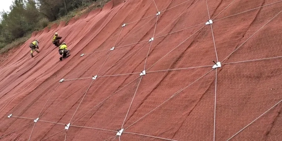
Stabilization Design and Instrumentation Plan
Design of regrading, drainage, retaining structures, or soil nailing; preparation of a monitoring plan with inclinometers, piezometers, and surface monuments for the construction and post-construction phase.
Typical parameters
Q&A
What triggers the requirement for a slope stability report in Maple Ridge?
The District of Maple Ridge requires a geotechnical stability assessment when your property is within a mapped hazard area, when the natural slope gradient exceeds 15% (approximately 8.5 degrees), or when proposed grading involves cuts or fills greater than 1.2 m in height. A Level C report with a registered professional engineer's stamp is mandatory for subdivisions and major building permits in these zones.
How long does a slope stability analysis take from start to approved report?
For a typical single-lot assessment in Maple Ridge, expect four to eight weeks. The timeline includes mobilizing a track-mounted drill for boreholes, installing piezometers, waiting for a representative rain event to capture groundwater response, running lab tests on undisturbed samples, and completing the iterative modeling. The municipality's peer review may add two to three additional weeks.
What is the typical cost range for a slope stability analysis in Maple Ridge?
The fee for a complete slope stability analysis in Maple Ridge, including drilling, lab testing, instrumentation, and the stamped report, generally falls between CA$1,620 and CA$5,860. The final figure depends on the slope height, number of boreholes, and whether a probabilistic seismic deformation analysis is requested.