The soil profile in Maple Ridge can shift dramatically within a few hundred meters. Along the Albion flats near the Fraser River, you encounter soft, organic silts that hold moisture like a sponge, while up in the Silver Valley benchlands, the glacial till transitions into stiff, overconsolidated clay with a completely different workability. This contrast becomes critical the moment you start earthmoving or placing a foundation. The Atterberg limits test quantifies that behavioral boundary—the water content where fine-grained soil changes from brittle solid to plastic putty, and then to viscous liquid. Without these numbers, a geotechnical report is just guesswork. For projects in Maple Ridge, where rainfall averages over 2,300 mm annually and the surficial geology includes Fort Langley Formation deposits, we run the grain-size analysis in parallel to confirm the fines fraction before measuring liquid and plastic limits. The combined dataset gives the engineer a clear picture of shrink-swell potential and drainage characteristics before a single bucket of excavation begins.
The plasticity index isn’t just a classification number—it’s a direct predictor of how a Maple Ridge clay will respond to seasonal groundwater fluctuations.
Scope of work
Area-specific notes
A 6-storey mixed-use project on Dewdney Trunk Road ran into trouble during foundation excavation when the contractor hit a lens of lacustrine clay that the preliminary borehole logs had classified as ‘low-plasticity silt.’ The material felt firm under the excavator bucket, but after a weekend of light rain, the exposed base became impassable and the shoring system showed signs of rotation. Subsequent Atterberg testing revealed a PI of 32 with a liquidity index above 0.8—meaning the clay was already close to its liquid limit in its natural state. This scenario is far from rare in Maple Ridge, where post-glacial silts and clays deposited in the former glacial lake environment can exhibit metastable fabric and pronounced sensitivity. Misclassifying a soil as ‘silt’ versus ‘clay’ has direct consequences: it alters the assumed drainage path, changes the lateral earth pressure diagram for retaining-walls, and can invalidate the slope stability model. The Atterberg limits test is the definitive method to make that distinction, and skipping it exposes the project to change orders, shoring redesigns, and winter shutdowns. Our laboratory runs the full multipoint liquid limit—not the one-point shortcut—to ensure the flow curve is statistically valid and defensible under municipal review.
Standards used
ASTM D4318-17: Standard Test Methods for Liquid Limit, Plastic Limit, and Plasticity Index of Soils, ASTM D2487-17: Standard Practice for Classification of Soils for Engineering Purposes (Unified Soil Classification System), CSA A23.3: Design of Concrete Structures (references soil classification for foundation design input), NBCC 2020: National Building Code of Canada (geotechnical investigation requirements for seismic site class)
Linked services
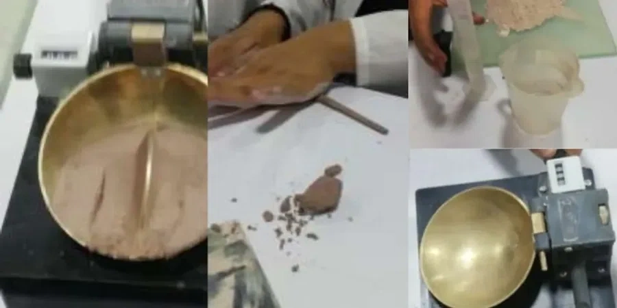
Full Atterberg Limits Suite with USCS Classification
Complete determination of liquid limit (multipoint Casagrande cup), plastic limit, and plasticity index on disturbed samples. Includes Unified Soil Classification System (USCS) assignment per ASTM D2487, with group symbol and group name. Delivered with a signed test report suitable for municipal permit submission in Maple Ridge. We use sodium hexametaphosphate dispersion for clay-rich samples to ensure representative particle-size distribution for the activity calculation.
Atterberg Limits + Moisture Content and Organic Content Correlation
Extended testing program for sites with suspected organic silts—common in the Albion flats and low-lying areas near the Alouette River. We pair the Atterberg limits with oven-dry moisture content (ASTM D2216) and loss-on-ignition organic content (ASTM D2974) to evaluate whether the soil’s high liquid limit is due to clay mineralogy or the presence of peat fibers. This distinction is essential for settlement analysis and for deciding between removal versus surcharge preloading.
Typical parameters
Q&A
How much does Atterberg limits testing cost in Maple Ridge?
For a standard Atterberg limits suite (LL multipoint, PL, PI) on a single disturbed sample, the cost ranges from CA$90 to CA$160, depending on whether it is part of a larger testing package and the required turnaround time. Samples requiring extended preparation—such as organic soil drying and pulverizing—may fall at the upper end of that range. We provide a firm quote once we review the number of samples and the project schedule.
How many Atterberg tests are needed for a typical Maple Ridge building site?
The number depends on the stratigraphic variability encountered in the boreholes or test pits. As a starting point, we recommend one Atterberg test per distinct fine-grained layer identified in the field log. For a single-family residential lot with 2 to 3 test pits, that typically means 3 to 6 determinations. For a multi-storey commercial development with deeper boreholes intersecting multiple glacial lake units, the count can exceed 15. The geotechnical engineer makes the final call based on the lateral consistency of the deposit and the foundation system under consideration.
What is the difference between the one-point and multipoint liquid limit methods?
The multipoint method (ASTM D4318, Method A) requires running the Casagrande cup at three or more water contents bracketing 25 blows, then fitting a flow curve to determine the liquid limit. The one-point method uses a single determination and a correction factor based on assumed slope. In Maple Ridge soils—particularly the Fort Langley Formation clays with liquid limits often above 50%—the one-point method can introduce a bias of 3 to 5 percentage points. Our laboratory runs the full multipoint procedure as standard practice, which produces a defensible flow curve and a more reliable plasticity index for slope stability and foundation design.
How do Atterberg limits relate to the plasticity chart in the Unified Soil Classification System?
The plasticity chart (ASTM D2487) plots the liquid limit on the horizontal axis against the plasticity index on the vertical axis. The A-line (PI = 0.73 × (LL - 20)) separates clays (above the line) from silts (below). The vertical U-line defines the upper boundary of realistic soil behavior. A Maple Ridge sample plotting above the A-line with LL > 50% classifies as CH—high-plasticity clay—which carries implications for shrink-swell potential, undrained shear strength, and the need for moisture conditioning during compaction. Our reports include the plotted point on the Casagrande plasticity chart so the reviewing engineer can verify the classification at a glance.