The geophone spread cable spools out across a cleared lot in the Albion area, near the banks of the Kanaka Creek. A 12-pound sledgehammer strikes an aluminum plate and the shot travels downward, refracting off the contact between glacial till and the underlying granodiorite bedrock that defines much of Maple Ridge’s subsurface. Seismic tomography, combining both refraction and reflection processing, turns these travel-time picks into a continuous velocity cross-section. For sites on the upland benches or near the Fraser River floodplain, the method resolves contrasts that standard drilling alone can miss. Where the water table sits high in the silty overburden—common from May through October in this part of the Lower Mainland—refraction tomography helps separate saturated low-velocity zones from actual weathered rock. A MASW survey run on the same spread can add shear-wave data for NBCC site classification, while the tomographic section guides the placement of test pits to ground-truth the interpretation.
A tomogram from Maple Ridge’s Albion bench showed a 6-metre-wide paleochannel that three boreholes had entirely missed—continuous imaging changes the foundation conversation.
Scope of work
Area-specific notes
Subsurface conditions change sharply between the flatlands of Port Hammond and the steeper slopes of Silver Valley. In the Hammond area, thick sequences of Fraser River sand and silt are susceptible to seismic amplification; a refraction-only survey can underestimate the velocity contrast if the water table is misinterpreted as rock. Up in Silver Valley, colluvium and weathered granodiorite produce complex first-arrival patterns that demand reflection processing to image deeper fracture zones. Skipping the tomography step and relying only on borehole logs risks placing foundations across a hidden step in the rockhead—a condition that has caused differential settlement in older Maple Ridge buildings near 224th Street. The NBCC 2020 places much of the municipality in seismic hazard zone 5, making accurate subsurface velocity models essential for any structure taller than two storeys.
Standards used
NBCC 2020 seismic provisions and site classification, ASTM D5777-18: Standard Guide for Using the Seismic Refraction Method for Subsurface Investigation, ASTM D7128-18: Standard Guide for Using the Seismic Reflection Method for Shallow Subsurface Investigation
Linked services
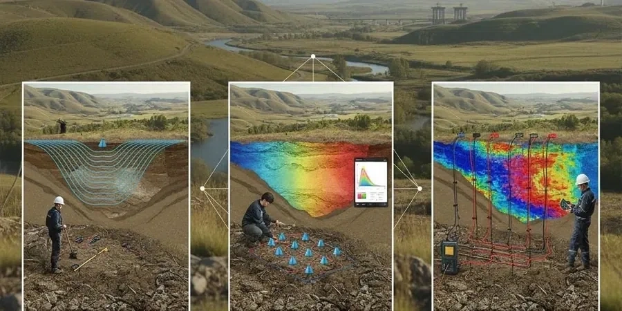
Seismic Refraction Tomography
Multi-shot refraction lines with ray-tracing inversion to map top-of-rock, rippability, and soil layering. Applied on the Maple Ridge uplands and floodplain for depths up to 40 metres.
Shallow Seismic Reflection Profiling
High-resolution P-wave and SH-wave reflection for imaging fracture zones, buried channels, and deep stratigraphy where refraction alone is ambiguous. Common on Silver Valley and Kanaka Creek corridor sites.
Typical parameters
Q&A
How much does a seismic tomography survey cost in Maple Ridge?
For a typical single-line refraction-reflection survey in the Maple Ridge area, the cost ranges from CA$3,620 to CA$6,810 depending on line length, source type, and number of shots. Longer multi-line grids or full-waveform inversion add to the scope and are quoted per project.
What depth can seismic refraction reach in Maple Ridge soils?
With a 24-channel spread and 5-metre geophone spacing, refracted first arrivals typically image to depths of 25 to 40 metres in the glacial till and silty overburden common across Maple Ridge. Larger energy sources extend that range beyond 50 metres in competent rock.
Does the survey require permits or traffic control in Maple Ridge?
If the seismic line crosses a public right-of-way, a street-use permit from the City of Maple Ridge is required. Surveys on private land do not need municipal permits, but the crew follows BC energy notification procedures before any mechanical source operation.
Can you combine MASW and refraction on the same line?
Yes. The same geophone spread can record both active-source MASW and refraction shots. The combined dataset provides a Vs30 profile for NBCC site classification and a P-wave tomogram for bedrock mapping, all from one field deployment.