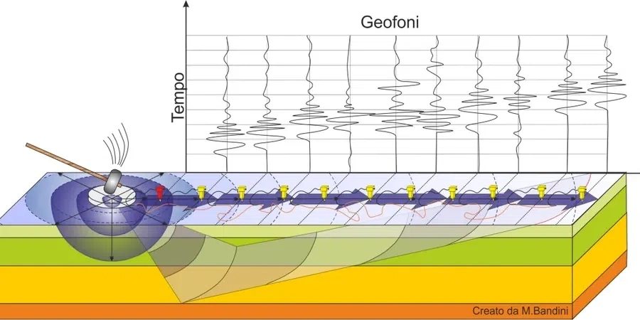
When we pull up to a site in Maple Ridge with our 24-channel seismograph and a string of 4.5 Hz geophones, the first thing we check is whether the line can run straight across the property or if we need to dogleg around a stand of western redcedar. The standard setup uses a sledgehammer source and a linear spread, but in the tighter lots near the Haney Bypass we often switch to a shorter receiver spacing to capture a clean dispersion curve without clipping the low-frequency end. The raw data feeds into a surface-wave inversion that gives us a one-dimensional shear wave velocity profile directly below the array. That profile—and the time-averaged VS30 we extract from it—is what structural engineers in Maple Ridge need for NBCC 2020 seismic site classification. We have run these surveys on everything from riverfront parcels along the Alouette to compacted industrial pads in Albion, and the subsurface variability across the city keeps the interpretation honest.
A well-resolved dispersion curve from 4 Hz to 40 Hz usually gives us VS30 within 5% of a downhole measurement—without the drilling cost.
Scope of work
Area-specific notes
The contrast between Albion and the Kanaka Creek flats is one of the sharpest we work with in Maple Ridge. Albion sits on a high terrace of glacial till and outwash: stiff, gravelly, with VS30 values routinely above 500 m/s, putting it in Site Class C or even B where the till is thin over bedrock. Drive ten minutes south toward the Fraser River and you are on soft, compressible silts and organics that can push VS30 below 200 m/s. That is a two-class jump in the NBCC table, and it roughly doubles the spectral acceleration the structure has to resist. Property owners who assume the whole city behaves like the uplands get a nasty surprise when the seismic report comes back with Site Class E. Running an MASW line early in the design phase—before the floor plans are locked—lets the structural team adjust the lateral system instead of scrambling for a costly redesign later.
Standards used
ASTM D4428 / D7400 — Crosshole and surface-wave seismic testing, NBCC 2020 Division B, Table 4.1.8.4.A — Site classification for seismic site response, CSA A23.3-19 — Design of concrete structures (seismic provisions referencing site class), ASCE 7-22 Chapter 20 — Site classification procedure (referenced in regional guidelines)
Linked services
Standard VS30 Site Classification
Single-line MASW survey with 24-channel acquisition, dispersion analysis, and 1D Vs profile for NBCC 2020 site class determination. Typical for single-family and low-rise residential developments east of 224 Street.
Combined MASW + Refraction Survey
Joint acquisition of surface-wave and P-wave refraction data along the same spread. We use the refraction bedrock velocity to constrain the MASW inversion, which reduces VS30 uncertainty on sites where the soil-bedrock interface is irregular—common near the Alouette River paleochannels.
Multi-Line Site Characterization
Two or three intersecting MASW lines to map lateral velocity variation across larger commercial parcels. Output includes a site-class map and representative Vs profiles for each building footprint, referenced to the NBCC site coefficients Fa and Fv.
Typical parameters
Q&A
How much does a VS30 MASW survey cost for a standard residential lot in Maple Ridge?
For a single-family or duplex lot in Maple Ridge, a standard single-line MASW survey with VS30 site classification typically runs between CA$2,340 and CA$3,100, depending on access and array length. Larger multi-line surveys on commercial parcels in Albion or along Lougheed Highway generally fall in the CA$3,800 to CA$4,720 range. Every quote includes data processing, the 1D shear wave velocity profile, and a signed report with the NBCC site class.
What is the difference between MASW and a downhole seismic test for VS30?
MASW measures surface-wave dispersion along a geophone array at the ground surface and inverts it to a Vs profile—no borehole required. A downhole test uses a triaxial geophone lowered inside a cased borehole and records arrival times from a surface source. Downhole gives a point measurement with excellent depth control, but it costs more because of the drilling. MASW covers a larger lateral footprint and averages out small-scale velocity variations. In Maple Ridge, we often recommend MASW for preliminary site classification and downhole testing where the stratigraphy is complex or where a borehole is already planned for geotechnical sampling.
How does the Fraser River floodplain affect VS30 values in Maple Ridge?
The low-lying areas south of the Lougheed Highway toward the Fraser River are underlain by thick sequences of Holocene alluvium—soft silts, clays, and peat layers—that transmit shear waves slowly. VS30 in these zones often falls between 160 and 240 m/s, yielding Site Class D or E depending on the depth to stiffer material. By contrast, the upland terraces north of Dewdney Trunk Road are underlain by Pleistocene glacial till with VS30 commonly above 360 m/s. The floodplain soils also amplify ground motion at longer periods, which matters for mid-rise structures. Our dispersion curves from these sites almost always show a sharp velocity inversion where the soft organic layer sits atop denser sand, and that inversion has to be handled carefully during processing.
What preparation does the site need before an MASW survey?
We need a cleared, roughly level strip about 50 to 110 metres long—grass, gravel, or compacted soil works fine. If the ground is heavily vegetated with blackberry thickets or has large surface boulders, we ask that it be cleared to mineral soil before we arrive. The geophones couple to the ground with spikes, so asphalt and concrete require drilling small pilot holes or using putty-coupled receivers. Heavy rain does not stop us, but standing water over half the array length degrades the high-frequency signal, so we may reschedule if the site is flooded. On sloped lots in Silver Valley we can run the line along the contour without any special grading. More info.